空港旅客体験と待ち行列分析
空港運営者向けに、待ち行列と旅客フローに関するリアルタイムのインサイトを提供し、旅客処理、ターミナル運用、サービスレベルの向上を支援します。
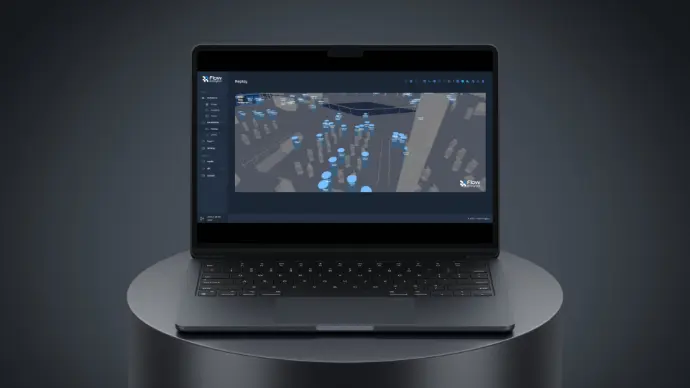
Flow Analytics by AGCは、プライバシーに配慮したLiDARとリアルタイム分析により、空港運営者が旅客体験と日々の空港運用を向上できるよう支援します。重要なターミナル接点における待ち時間、待ち行列の長さ、処理能力、密度、滞留時間、サービスレベルをモニタリングすることで、より早い対応、旅客動線におけるストレスの軽減、ピーク時や混乱発生時のターミナル運用の予測可能性向上を実現します。
重要な旅客処理エリア全体の旅客フローをモニタリングする
旅客体験は、ターミナル全体で一日中繰り返されるプロセスによって形づくられます。チェックイン、保安検査、出入国審査、搭乗、そしてそれらの間を人々がどれだけスムーズに移動できるかが重要です。 待ち行列が想定外の動きをしたり、人の流れが滞り始めたりすると、ストレスは急速に高まり、その影響は空港運用全体へと広がります。
Flow Analytics by AGCは、現場チームがリアルタイムで状況を把握し、どこで負荷が高まりつつあるかを理解し、サービスレベルの低下やボトルネックがターミナル運用に影響を及ぼす前に対応できるよう支援します。
チェックインから搭乗まで、Flow Analytics by AGCが空港で最も重要な場所のフローをどのようにモニタリングできるかをご覧ください。
✔
出発ロビー
混雑が過密状態となり、旅客の移動を妨げる前に検知します。
✔
チェックイン・手荷物預け入れ
ピーク時間帯における待ち行列の長さ、待ち時間、処理能力を把握します。
✔
保安検査
待ち行列の増加を早期に検知し、レーン変更や人員配置の効果を追跡します。
✔
搭乗管理・出入国審査
サービスレベルをリアルタイムで測定し、時間帯や到着パターンごとのボトルネックを特定します。
✔
搭乗ゲート
密度、滞留時間、フローのパターンをモニタリングし、搭乗エリアの予測可能性を維持します。
空港混雑管理の最近の導入事例
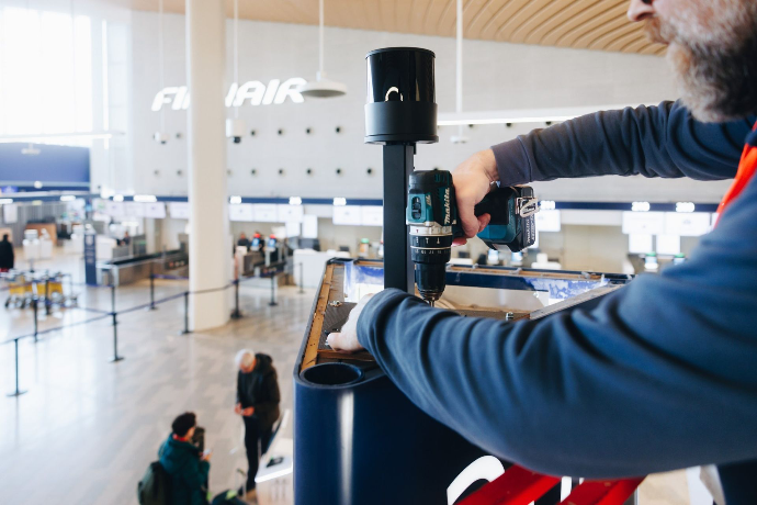
Flow Analytics by AGCは、ヘルシンキ空港の出発ロビーに導入され、旅客フローのモニタリングに活用されています。LiDARベースのシステムは、旅行者がさまざまな動線エリアをどのように移動しているかを追跡し、待ち時間のリアルタイム表示、密度ヒートマップ、滞留時間に関するインサイト、運用状況の可視化を提供します。 このプロジェクトは、プライバシーを保護しながら、より安全な運用、ターミナル性能の向上、旅客体験の改善を支援します。
ターミナル全体で測定する項目
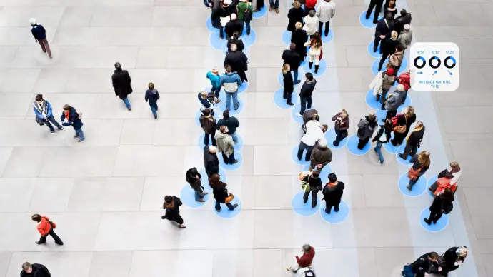
待ち行列モニタリング
各待ち行列について、並び始めからサービス提供までを追跡し、待ち時間、待ち行列の長さ、処理能力、サービスレベルのパフォーマンスを把握します。 旅客処理におけるボトルネックを早期に発見し、その影響を定量化するとともに、運用変更後の改善効果を検証します。
滞留時間分析
待合エリアや主要ゾーンでの滞在時間を測定し、サービス、レイアウト、商業計画、旅客案内の改善に向けたリスクと機会を明らかにします。
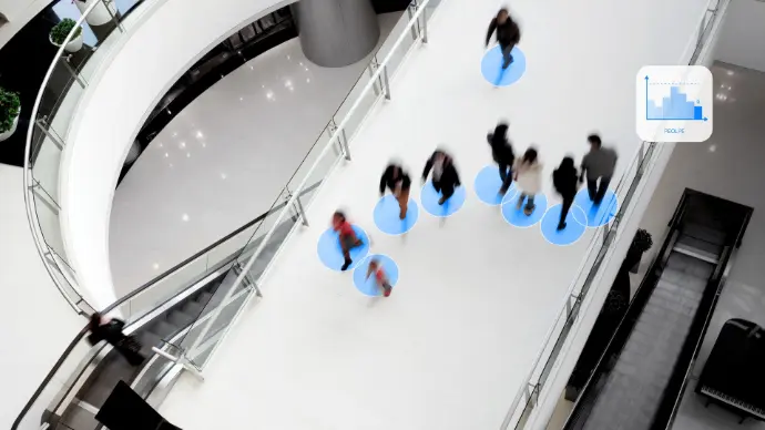
フロー追跡
入口、チェックインエリア、保安検査場、出入国審査、出発ロビー、コンコース、ゲートにわたるターミナル全体の旅客フローを可視化します。どこで混雑が発生しているか、ゾーン間で負荷がどのように移動しているか、旅客フローがターミナル運用にどのような影響を与えているかを特定します。
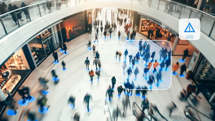
クラスター検知
混雑密度を継続的にモニタリングし、エリアが安全性や快適性の面で望ましくない混雑レベルに近づいた際にアラートを発します。これにより、運用上の意思決定と管制室での状況把握を支援します。
仕組み
なぜLiDARなのか?従来の映像解析を超えて
多くの空港運営者は、空間的なインテリジェンスではなく、セキュリティを目的として設計されたカメラベースのシステムに依存しています。映像は識別には優れていますが、現代のターミナルのような複雑で高密度な環境では限界があります。Flow Analyticsは、3D LiDARを活用して、実態に基づく正確なデータを提供します。
「遮蔽」問題の解決
混雑した保安検査の待ち行列では、2Dカメラには人々が「画素のかたまり」として映ります。背の高い旅客が子どもの前に立つと、その子どもはカウントから消えてしまいます。
当社のLiDARソリューションは、高精細な3D点群を生成します。パルスが三次元で伝わるため、肩が触れ合うほど混雑した状況でも、システムは個々の旅客を識別できます。 ターミナルがどれほど混雑しても、旅客フローの「デジタルツイン」を取得できます。
画像ではなく、実用的なインテリジェンス
映像解析では多くの場合、高精細映像を処理用サーバーへストリーミングするために、大容量の帯域幅が必要になります。
- エッジ処理: 当社のLiDARセンサーは、データを取得元で処理します。
- 低帯域幅: ダッシュボードには匿名化されたデータのみが送信されます。
- リスクの最小化: そもそも収集していないデータは、漏えいすることもありません。データストリームから「人の顔」を取り除くことで、旅客追跡に伴う主要なサイバーセキュリティリスクを排除します。

個人データを取得しない設計の、プライバシーファーストなセンサー。

同じシステムからリアルタイムおよび過去データに基づくインサイトを提供します。

混雑したターミナルや変化する運用条件下でも信頼性の高い性能を発揮します。
空港チームが得られるもの
空港チームが支援できる運用アクション
Flow Analytics by AGCにより、空港運営者は以下を実現できます。
- 待ち行列がリアルタイムで発生しつつあるエリアへスタッフを再配置する。
- リアルタイムの密度およびフローデータに基づき、旅客案内、サイン表示、またはアナウンスを調整する。
- レーン変更や処理方法の調整について、変更前後のデータに基づいて評価する。
- 実際の利用データに基づき、ターミナル計画および空港容量計画を支援する。
- 安全性および混雑管理に関する要件への適合を示す。
駐車場から搭乗ゲートまで、旅客動線を改善
from Parking to Gate
Flow Analytics by AGCは、ターミナル内の人流と空港駐車場の両方に対応するソリューションで空港チームを支援し、到着から出発まで、よりスムーズで予測しやすい旅客動線の実現に貢献します。
空港運営者がFlow Analytics by AGCを選ぶ理由

プライバシーファースト
当社のソリューションは、顔、個人識別情報、個人データを取得しません。匿名化された3D LiDARデータを活用するため、公共空間やプライバシーへの配慮が求められる空港運用に適しています。

高精度かつ詳細
複雑な旅客環境においても、人の動きを高い精度で追跡し、信頼性の高いカウント、密度測定、滞留時間分析、移動軌跡に関するインサイトを提供します。

実環境で実証済み
混雑したターミナルや変化する条件下でも性能を発揮するよう設計されており、正確なリアルタイム可視化が求められる運用現場で、安定したインサイトを提供します。
運用と計画に活用可能
当社は、生データの提供にとどまりません。日々の意思決定、ターミナル計画、長期的な改善を支援する運用ダッシュボード、レポート、構造化されたアウトプットを提供します。